Introducing Snapshot: Turn project data into stakeholder-ready visuals in seconds

There's a moment most infrastructure professionals know well. You've spent months on a project. The survey data is solid. The engineering is sound. The design works. You walk into a planning committee, a community consultation, or a board presentation and watch the room disengage.
Not because the project is flawed. Because the project isn't understood.
Point clouds, CAD overlays, and elevation models are essential for delivering infrastructure projects. But to a landowner, local councillor, permitting agency, or community stakeholder, they can be difficult to interpret.
When people can't understand what they're looking at, they ask more questions, raise more objections, and take longer to make decisions.
Projects rarely stall because the data is wrong. They stall because the data doesn't communicate.
The challenge isn't the quality of the project information, infrastructure teams already have the data they need. The challenge is turning that information into something non-technical audiences can immediately understand.
That's where Snapshot comes in.
Snapshot generates photorealistic visuals directly from the project data already inside your Sensat workspace, helping teams communicate proposals more clearly without waiting weeks for external rendering support.
The visualisation bottleneck
For years, communicating infrastructure projects visually has meant outsourcing the work. Teams brief specialist rendering consultants, wait days or weeks for imagery to be produced, and often spend significant budget creating visuals that can quickly become outdated as designs evolve.
The teams closest to this problem know it best. One Director of Community Relations working on major transmission infrastructure put it simply:
"Generating visual renderings is always like a whole other thing... it can be really slow to get from our contractors."
A Director of Permitting Compliance described spending significant budget on imagery for planning hearings, and reflecting that faster access to comparison visuals, towers versus right-of-way expansion, for example,
“Would have been awesome for community relations and agency discussions."
This isn't a niche problem. It's a structural one. The people who need to communicate projects to non-technical audiences are almost never the same people who have access to the spatial data those projects are built on. And even when they do have access, translating that data into something a room full of non-engineers can understand has always required a specialist, a budget, and time you rarely have.
Your project data, ready for the room
Snapshot changes that equation.
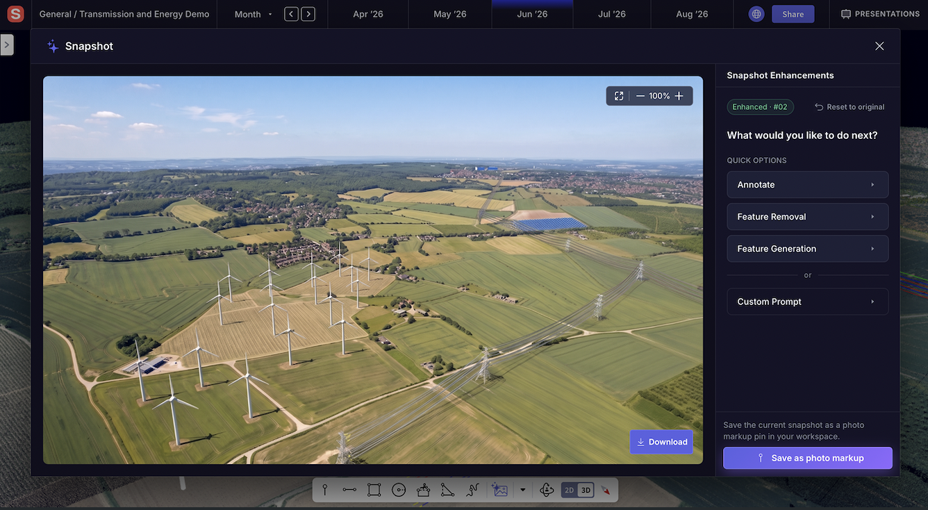
It works directly on your real project data: the point clouds, CAD files, and markups already inside your Sensat workspace. You select an area, set the scene (weather, time of day, season), and generate a 2K presentation-ready visual in seconds. Not a generic AI render. Not stock imagery. A photorealistic image of your actual project, in its actual location.
.jpg)
.jpg)
Because it's built into the workspace, every image is location-pinned. Colleagues can see exactly where in the project it was captured. You can refine specific areas using the brush tool without having to regenerate from scratch. You can label infrastructure features directly in the image so non-technical audiences immediately understand what they're looking at.
The result is a visual that could sit in a planning pack, a community briefing, or a board deck, produced by your own team, from your own data, in the time it used to take to write the brief to a consultant.
Who it's for
Snapshot is now open to Project Member level across all accounts. That means the outreach lead, the permitting manager, the community relations director, the people who actually need to present to stakeholders, can generate visuals themselves, without waiting for an engineer to do it.
A Principal Analyst at a major energy infrastructure operator summed up what that access means in practice:
"Snapshot is going to be a lot faster and more cost-effective way of producing slick imagery than the current way our outreach and permitting teams do it."
Helping projects move forward
Infrastructure teams already have the data they need to explain their projects. What they often lack is a fast, practical way to turn that data into something stakeholders can understand.
Snapshot closes that gap by enabling teams to generate project visuals directly from the data already inside Sensat, reducing reliance on external rendering support and making stakeholder engagement easier to prepare for.
Whether you're presenting to a planning committee, consulting with local communities, engaging permitting agencies, or briefing executives, Snapshot helps you communicate project context more clearly and move conversations forward faster.
Try it in your project → login here.