What Google Earth's AI rollback teaches about trustworthy site visuals
Infrastructure teams rely on visuals grounded in real data and under human control. Here's what building Snapshot, a Sensat AI feature, taught us about getting there.
Words by Sheikh Fakhar Khalid, Chief Scientist & Head of Sensat Labs
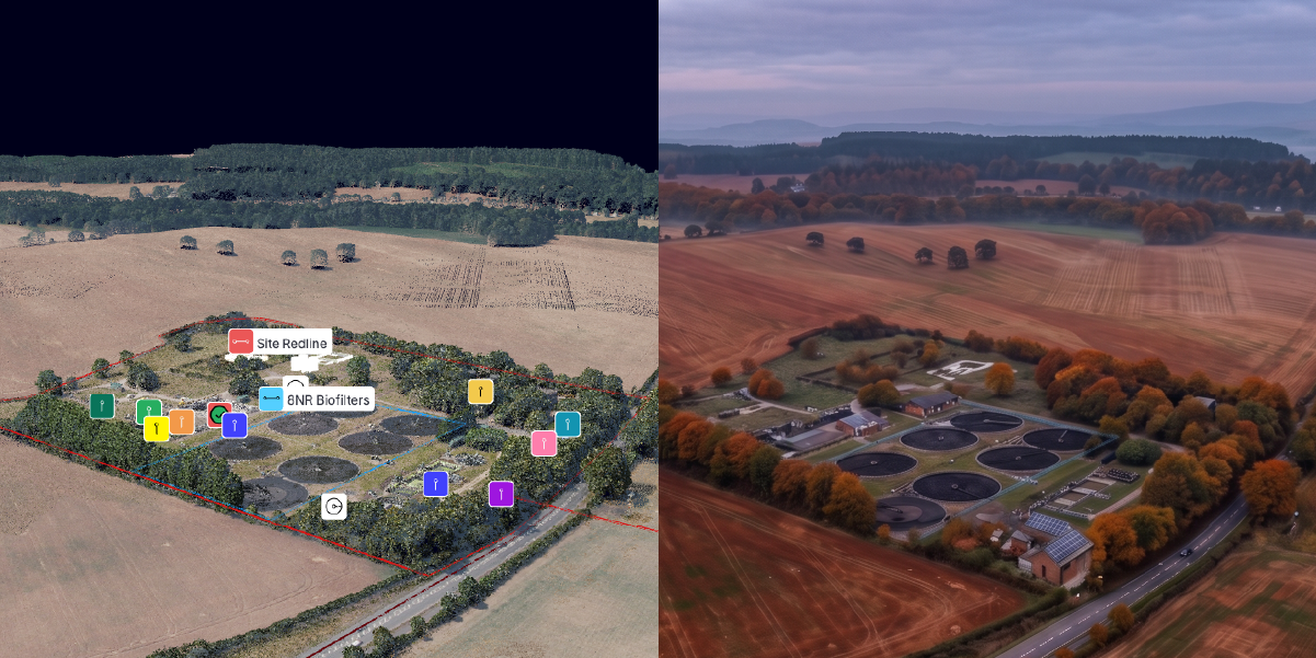
Why Google Earth pulled its AI image tool less than 48 hours after launch
Last week Google added an AI image button to Google Earth. Zoom to any spot on the map, describe what you want to see and it would generate a photorealistic image grounded in Google's satellite, aerial and 3D geospatial data.
It didn’t last two days.
Researchers used it to fabricate convincing images, at real and sensitive locations, of events that never happened. Google pulled the feature and said it would return once it had stronger safeguards in place.
This was worse than a bad launch. Google Earth isn't just a map. It’s a reference people treat as the truth. After the rollback, former Google geospatial technologist Ed Parsons put it plainly: geospatial trust is "hard to win and terrifyingly easy to lose."
The images themselves were impressive. The problem was putting an image generator inside the tool people use to check what's real. As Parsons argues, a platform like that works as a reference, not a canvas. People come to verify reality, not reimagine it. And the moment anything on screen can be invented, nothing on it can be fully trusted.
Start with the job, not the model
Before building any new feature, there's a question worth answering honestly: what job does this help someone do better? That question seems to get asked less often when the feature is AI, simply because AI is trending. The Google Earth episode is what happens when that question goes unanswered. As Parsons implies, the feature existed because the model could, not because it made anyone's work better. Dropping generation into a tool people trust, with no real job for it to do, doesn’t add value.
We had to answer that question ourselves when we first launched Snapshot, a Sensat AI feature that lets users create ultra-realistic snapshots of any viewpoint in the platform. Our reason was clear from the start: help delivery teams show a real project to the people who need to understand it. Infrastructure teams trust Sensat to represent their sites accurately, and that trust is the foundation of everything. A generated image that quietly misrepresents a site isn't harmless fun. It ends up in a planning pack, a community consultation or an agency submission, shaping a decision it shouldn't.
Consumer generation exists to reimagine the world. Infrastructure visuals exist to do a job, and that only happens if the tool is built to serve it.
Those early lessons are what shaped Snapshot into the way it works today.
What Snapshot v1 got wrong
We launched Snapshot in December 2025, alongside Orion, our physical-world search engine. The pitch was simple: turn spatial data into ultra-realistic visuals of the project, from any viewpoint, on demand.
It did that, but what it didn't do well was let users steer the result.
Our R&D engineer, Mark, put it simply. If users tried to direct the image with a prompt like "add a marker in the top-left corner”, it had no understanding of where the top-left actually was. This was due to a lack of understanding of the scene's spatial structure. It wasn't reasoning about the scene. It was simply generating an image from patterns it had learned. The result was often an approximation. The marker might appear somewhere in the frame, looking plausible, but not in the precise location intended.
For a consumer toy, that's fine. For a visual that a team might put in front of a council or a regulator, "close enough" isn't good enough.
What we took from it
The lesson wasn't "make the model better at guessing." Our customers work in reality and their data has to match.
When an image informs an infrastructure decision, realism alone isn't enough. It has to be grounded in the actual project and the users need precise control over what is represented.
How we gave users more control over AI image generation
The fix was to stop asking the model to guess what users meant.
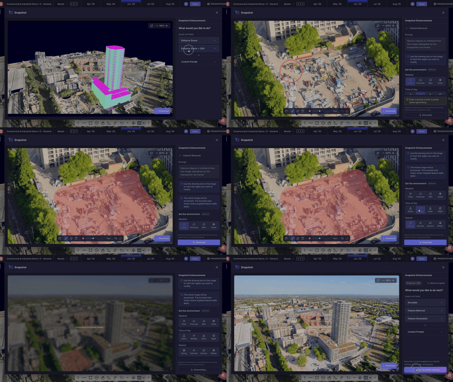
Instead of a text box and a hope, we built a canvas. Users define exactly where a change should happen, and the AI works from that explicit spatial context. It works from the region they selected, not the region it inferred. As Mark puts it, it’s like Adobe Express, for a construction site seen from 400 feet up. Visual, direct and accessible without specialist software skills.
Getting there wasn't just an engineering challenge. It required continuous collaboration between engineering, design and product, asking not only what the technology could do but how it can enable the user. That is the difference between a capable model and a feature a permitting manager can actually use on a Tuesday afternoon.
How Snapshot works today
Today, Snapshot generates directly from real project data already in a user’s workspace, from point clouds and CAD to markups. Every output is grounded in the project. Not a generic AI rendering, but a true reflection of an asset’s spatial reality.
Because Snapshot operates within the workspace, not outside it, every output remains grounded in trusted project data and under the user's control.
- It's anchored to reality. Every image is pinned to its real world location, so collaborating users can see exactly where in the project it was created.
- Users stay in control. Create the initial image by defining the environmental conditions, then iterate with precision. The brush tool lets users regenerate only the areas that need to be changed, leaving the rest of the image untouched.
- It puts the capability in the right hands. Snapshot is available to everyone with Project Member access, enabling outreach leads, permitting managers and community relations teams to create their own visuals without relying on engineers.
- It communicates clearly. Add labels directly to infrastructure features within the image, helping stakeholders who don't work with technical drawings or models understand the project instantly.
Every one of those choices traces back to the same idea. The value isn't an image that merely looks real. It's an image that can be trusted, because it's grounded in spatial data and connected to the real project data.
Does AI project visualisation actually work?
The problem Snapshot solves is one most infrastructure teams know well. Communicating a project visually has traditionally meant briefing a rendering consultant, waiting days or weeks, spending budget, and often receiving imagery that becomes outdated as the design evolves.
As one Director of Permitting Compliance at Avangrid put it:
"We've previously spent significant budget on imagery for past project hearings. If we had the ability to generate visuals comparing towers vs Right of Way (ROW) expansion in minutes, this would have been awesome for community relations and agency discussions."
.svg)
Since the new version launched, teams have adopted it quickly. In July, users generated 446 Snapshots (up from 58 in June) and saved 90, compared with 14 the previous month. In its first full month, the new version produced close to as many images as the whole lifetime of v1.
More importantly, the reaction changes when a project can be seen rather than described:
"Our team loves the fact we can generate realistic snapshots directly from our technical project data, without the need to engage a 3rd party consultant - it massively helps communicate the plan to our leadership and external stakeholders. Thanks Sensat, this is a game changer!" - Project Manager, UK Energy company
The point
AI can generate convincing images of almost anything. But infrastructure decisions aren't made in imagined worlds, they are made in the real one. The challenge isn’t making AI create more; it's making AI understand what must remain true.
We built a tool that starts with a real project, preserves its connection to reality and lets the user decide how it’s communicated, rather than one that invents a plausible scene and hopes it's close enough. That's the difference between a visual gimmick and something our customers can put their name to in front of a planning committee.